Fox River Fishing Maps

From the Wisconsin border to the Illinois River, some of the best and easily accessible fishing in the Chicago area.
Post Reply
User avatar
Ken G
Posts: 2083
Joined: Tue Jan 15, 2008 11:01 pm
antispam: No
Type in the middle number (1118): 1118
Location: Montgomery, IL
Contact:

Fox River Fishing Maps

Post by Ken G »

In 1989 a friend gave me a copy of Ed Mullady's Kankakee River maps. I loved the whole look of them with their hand drawn details and profiles of the types of fish you can catch out of specific spots on that river. I didn't fish much back then, went to the Kank once, didn't catch anything and didn't go back for almost 10 years. In 1996 I fished the Fox River for the first time and river fishing became an obsession. I looked around for the equivalent type of maps for the Fox River and they didn't exist. So I decided to fish the river a lot and make my own.

Image

Image

Image

Image

Image

Image

Let me know if you can make out these maps okay. On my screen everything is pretty clear and readable.

About 12 years ago, after about 2 years of fishing the Fox, I started collecting maps of the whole river system. Back then there was only one booklet available with detailed maps, but the guy only concentrated on the dams. Which I don't fish. I knew right off they were outdated even then when he had a lot of markings for pike, which are virtually non-existent in the areas he said they were in. And, one point in North Aurora was marked as a good spot for pike that was in ankle deep water. Oh kay.

In 1999 I started downloading and piecing together black and white aerial photo's. There was only black and white back then. I have the whole river pieced together from Elgin to Millhurst. I also collected all of the topo maps for pretty much the whole river. The plan was to do a hybrid map consisting of the aerials, topo maps and hand drawn details from my fishing trips. I have a whole magazine style layout of a few sections done.

This initial map book was done in 2002. It was quick and dirty, but served the purpose at the time. I never took it any further because I wanted things in color.

First Version of Fox River Fishing Maps

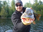
With the slow computers back then, the whole thing turned into a time consuming venture. It was cutting into my fishing time. So I shelved it somewhere in the back of my head and continued on with the research. Can't mark maps if I don't cover as much river as possible. My peak year of fishing in general was I think 2003, when not only did I fish just over 250 days out of the year, but about 150 of those were on the Fox.

A few years ago I did the same thing again with the aerial photos only this time in color. I concentrated on the stretch from Geneva down to around Millbrook, the areas I fish the most and like the most. Got them all together and started a new magazine style layout.

Still not good enough.

The speed of the computers are now up there and the quality of aerial photos are much better. Now things are close to what I started to picture in my head almost 12 years ago. Still not quite what I picture, but it might be close enough.

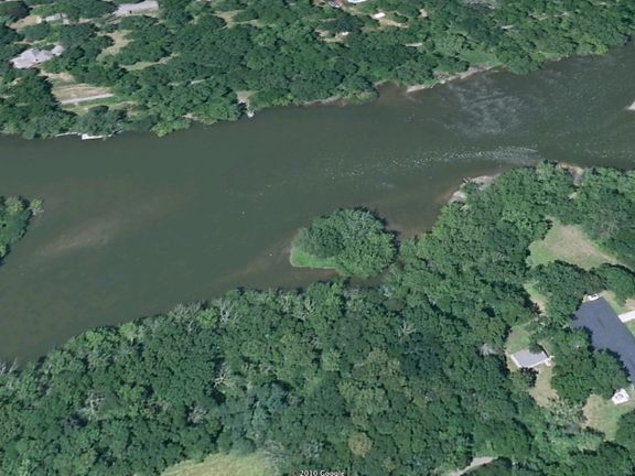
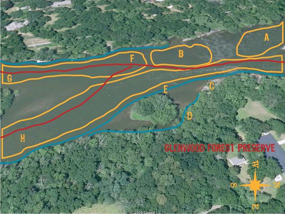
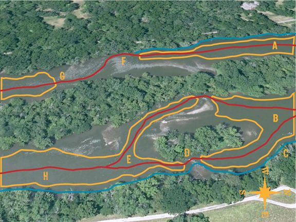
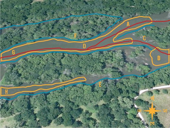
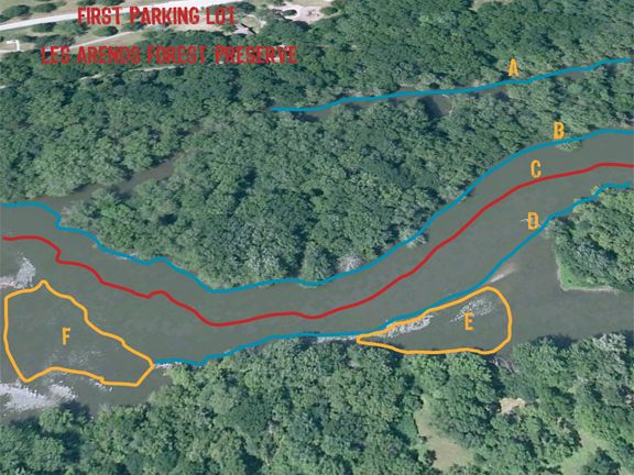
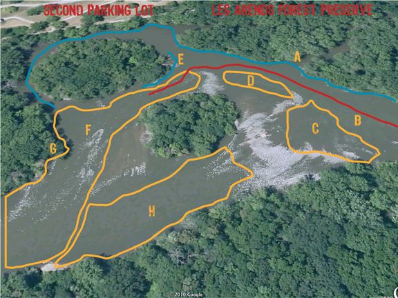
The problem now is that the best maps of the Fox, birds eye views that you can get from Bing maps, were all shot when the river was at flood stage. Totally useless. You can't see any of the current breaks and rock bars. The whole river looks like one big flat piece of water. Which it's not. So, on Google Earth you can get kind of a hybrid birds eye view. Not what I had in mind, but you can see all the details of the river that are important to key in on. I'll have to wait for the next version of birds eye views and hope they shoot them at low water. New ones come up every few years. I should have these done by then. :D

I can do this kind of detailed information for the wadeable sections of the Fox from the Geneva dam all the way to the Yorkville dam. Obviously that leaves out the areas that start turning into the pools above the dams. From some canoe trips I've taken, I can even detail at least one worth while stretch that most will never see. I also can do this for quite a few miles of the river below Yorkville. This year I hope to add a couple of more miles to my mental collection. We'll see.

I have a lot of the details worked out in my head. They're extensive. I have this pictured as both a book and an interactive piece. I work in the print world. That one is easy for me. The other is a challenge, but not impossible.

So, let me know what else might be worth adding to the aerials without them getting too cluttered. I already realized I need to add a compass rose. Each line and shape have corresponding letters. Each one of these would be expanded on with details on how to fish them and what to expect, keyed to the letters. Somewhere in my collection I have stories that almost cover all of the river. Plus hundreds of photos. Those too would be incorporated some how.

Now I need a good two years full time to complete it. More research to cover the few hundred yards I haven't waded in that long stretch and more photos to go take. Then on the the miserable days where it's not worth being out, which is most of winter and some just butt ugly days, sit and hack out the words needed for each section.

And when that's done, start on the Book of Fox Creeks.
Ken G
Stand still like the hummingbird.
http://www.waterdogjournal.com
http://kengortowski.com
John S Montgomery
Posts: 76
Joined: Thu Mar 04, 2010 10:45 pm

Re: Fox River Fishing Maps

Post by John S Montgomery »

Sounds pretty damn good. Time consuming for sure. Sounds like it could be used as universial tool ,such as fishing of course , but also canoeing , hunting etc. I have not seen anything that well scripted or detailed on the Fox river system. The only thing I've seen is that book that they sell at Gander Mtn that gives the plain basics on Illinois waters. Count me in for buying one. I think it would sell pretty good for the different reasons I mentioned. Throw in some of the great Pic's you have taken. Your name is already established in the outdoor community. Sounds good!
User avatar
Special Ed
Poop Ninja
Posts: 763
Joined: Mon Sep 28, 2009 12:21 pm
Type in the middle number (1118): 630
Location: Oswego, IL

Re: Fox River Fishing Maps

Post by Special Ed »

I would like to know if the river would change enough over the years of flooding/receding for these maps to be obsolete eventually?

If so, maybe more generalized location descriptions would help this last a bit longer.


Otherwise, I love the idea, and the aerial pics are the coolest.

I was driving past Blackberry creek the other day and watched a guy park and walk towards the creek with a handheld gps and his dog. For some reason it made me think of how the world has opened up to me via Google Earth and my Garmin GPS. These two tools have taken away all of the inhibitions I once had about exploring new areas.

Maps like the ones you show here would make it even that much easier to formulate a gameplan with a high potential for success for each outing.


Very cool Ken.
pezdek1
Posts: 121
Joined: Tue Jun 02, 2009 10:10 am
Type in the middle number (1118): 630
Location: South Side!
Contact:

Re: Fox River Fishing Maps

Post by pezdek1 »

Very cool idea Ken. Looking at your maps pictured above I recognize all the waters, riffles, etc. from our outing last year. I'd love that compass rose, and legend, in order to know what each letter/colored line means :D . Good start Ken. It will turn out really nice when completed.
User avatar
Ken G
Posts: 2083
Joined: Tue Jan 15, 2008 11:01 pm
antispam: No
Type in the middle number (1118): 1118
Location: Montgomery, IL
Contact:

Re: Fox River Fishing Maps

Post by Ken G »

Special Ed wrote:I would like to know if the river would change enough over the years of flooding/receding for these maps to be obsolete eventually?
When the lower Batavia dam breached all the sediment that washed down from above changed the first couple of hundred yards, but not that much. And It added more land to the backs of islands much further down stream. Other than that, in 14 years if things have changed, I don't notice it. I've gone back to spots I haven't fished in 4 or more years and it's like I was there yesterday. Maybe in a couple of generations you'll notice something, but I doubt if in mine.

John, thought of that. The red line indicates the deepest part of the river. Worth fishing, but be cautious. For canoers that would be worthwhile info. For the Orchard Road through Silver Springs section I plan on incorporating the map of public blinds available through there and how to access those.

Nick, now that I know the lines and letters are readable, I'll have to work on the descriptions. The really good birds eye aerials I wanted to use were all taken at flood stage. Can't see a single riffle or rock.

It's a daunting task. I should take one small section and finish it every other week. Even then it's a lot. I should have started this back in November when I quit fishing for the winter instead of attempting it when things are just starting. I was a little preoccupied over the winter though.

Even one of these small sections is going to make big posts. Description, pictures, story . . . all adds up.
Ken G
Stand still like the hummingbird.
http://www.waterdogjournal.com
http://kengortowski.com
User avatar
Ken G
Posts: 2083
Joined: Tue Jan 15, 2008 11:01 pm
antispam: No
Type in the middle number (1118): 1118
Location: Montgomery, IL
Contact:

Re: Fox River Fishing Maps

Post by Ken G »

Okay. I put up a few more maps in the above post. Let me know what you think.

As I was putting all the lines on them I started to think they were looking cluttered. But the letter keys directly relate to the lines or the shapes. The keys will be used for the verbal descriptions and the lines and shapes make that description easier on me.

So if you look at the first two pictures, this is how I may do this. First just the picture of the area alone. Nothing on it. Second picture would have all the lines and shapes and letter keys on it. That way you can make the comparison. Also, if I give a clean picture it gives people a chance to print it or copy it and mark it up with their own notes.

Or something like that.

I mark up maps all the time with my own notes.

Am I getting close or what?

If you look at the post below this one called Fox River Map, I had already planned on doing something similar. Funny to look at that old one from 2002. You couldn't get color aerials on line back when I started doing that one. Or if they were available, I was on dial up back then. Wasn't worth the time.
Ken G
Stand still like the hummingbird.
http://www.waterdogjournal.com
http://kengortowski.com
User avatar
Special Ed
Poop Ninja
Posts: 763
Joined: Mon Sep 28, 2009 12:21 pm
Type in the middle number (1118): 630
Location: Oswego, IL

Re: Fox River Fishing Maps

Post by Special Ed »

Awww man, Mr. Sociopath's carotid artery will ExPlOdE when he sees these!!!!


Oh the fun!
smallmouthfisher
Posts: 139
Joined: Thu Jul 16, 2009 5:33 pm
Type in the middle number (1118): 630
Location: Joliet IL
Contact:

Re: Fox River Fishing Maps

Post by smallmouthfisher »

Ken Great map Now i need to make mine look like yours.
User avatar
Ken G
Posts: 2083
Joined: Tue Jan 15, 2008 11:01 pm
antispam: No
Type in the middle number (1118): 1118
Location: Montgomery, IL
Contact:

Re: Fox River Fishing Maps

Post by Ken G »

smallmouthfisher wrote:Ken Great map Now i need to make mine look like yours.
I've been working with images this way for over 25 years. Do it every day for a living. Easy and quick for me, more or less. :D :D :D

Right now I can only use these images the way I'm using them. That's what the license allows. I'm hoping to scratch the $500 license fee together this year so I can get better images, use them however I want and resell the end result.

If I have the time I'll go and match what you sent me. The real bird's eye view you used is much better. The DuPage wasn't flooded when they shot those. Problem with the birds eye view for the Fox is that they shot them all at flood stage. Which makes them useless. Can't see any details.
Ken G
Stand still like the hummingbird.
http://www.waterdogjournal.com
http://kengortowski.com
Post Reply